Last year Transport For London consulted on plans for Cycle Superhighway 1, which I
looked at in detail at the time. Construction started almost exactly a year ago and I had always assumed it was due to be completed before Boris Johnson left office, just as the other Superhighways consulted on around the same time were. According to the
TFL road modernisation page CS1 is listed as "delivered in April 2016", which is also reiterated
in this TFL press release but as you'll see in this post it is far from finished according to the original consultation, although no works have taken place on it since around April. I ideally wanted to wait until it had been fully completed before reviewing it but as it looks like it could be many months, or perhaps even years, before all construction work is completed I'll review it as it is now and then try to come back and write about any more sections that are completed at a later date.
Although Cycle Superhighway 1 was a TFL consultation and paid for from the Mayor of London's "cycling vision" budget the Hackney section of CS1 was designed by Hackney Council and delivered by its contractors.
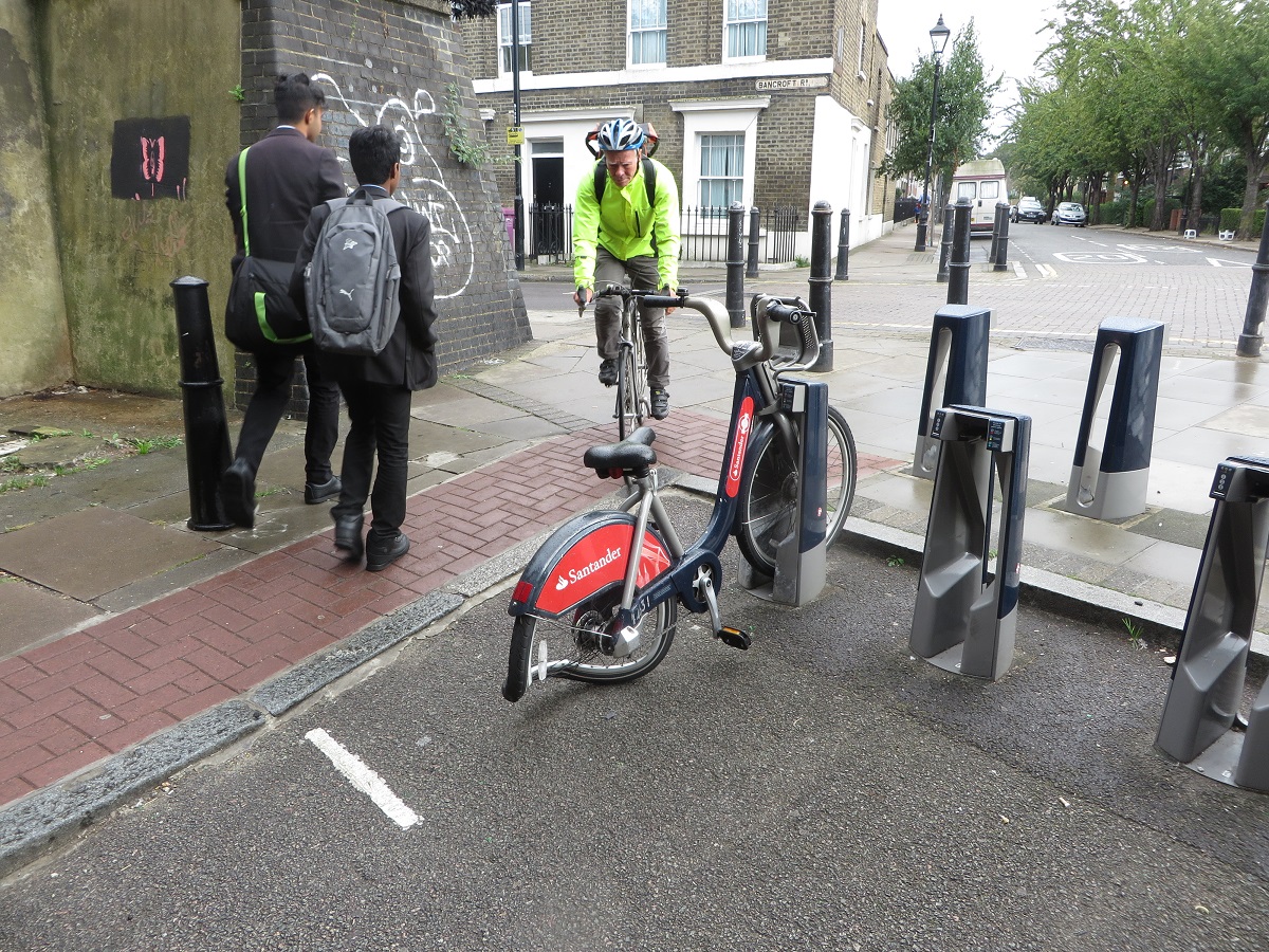
Section 1
The only change that was planned for the start of the route (or end, depending on which way you're travelling) was for "Signs to highlight the start and end of CS1". A symbol of a bicycle with "CS1" written under it does now exist, painted onto the road at the beginning of Wilson Street (the first of many along this route). A new sign stating that this is Cycle Superhighway 1 is also attached to the lampost informing you that Hoxton (roughly half a mile away) is a 5 minute cycle, cycling to Dalston (around two miles) will take 13 minutes and it is 35 minutes to cycle to Tottenham (nearly five miles away). Therefore the assumption is that you'll be travelling at an average speed of between 8 and 11mph along here; I would personally have preferred it if these signs displayed distances rather than times as obviously not everyone cycles at the exact same speed. Despite the promise there is no sign to mark that you have reached the end of CS1, just an ASL at a busy crossroads in the city with no indication as to where to go next. Assuming you want to travel west into the City or the West End then your choices are to either carry on to the end of Wilson Street where you'll eventually end up on either London Wall or on Moorgate, both very busy, hostile streets with no cycling provision provided, despite their widths. The most popular option is to turn right
into Finsbury Square and a very unpleasant squeeze through three lanes of traffic and parked cars; a route I used to take everyday and am thankful I no longer have to. Although hopefully
Islington Council will provide some much needed cycling infrastructure here one day in the near future. Or perhaps,
like the City of London, they won't.
Back on CS1 and in the consultation Wilson Street was to be closed to through motor traffic between Worship Street and Dysart Street using two sets of bollards:
But none of this has happened, although the road has, bizarrely been resurfaced with the car parking spaces that were meant to be removed repainted alongside "CS1" signs on the carriageway. There was nothing in the response to the consultation to declare that this scheme would not happen so not sure why this has not been constructed as detailed or why CS1 is listed as "delivered" on the TFL website when there are clearly some fairly major omissions. In the response to this consultation it was declared that they would "
remove the bollard from the junction between Wilson Street and Christoper Street, improving access to Finsbury Square for cyclists" but this still hasn't been done, despite seeming like quite a simple piece of work to do.
When I looked at this scheme last year I suggested that CS1 should take priority over Worship Street but unfortunately this was not considered and so it remains difficult, and indeed dangerous, to cross the road on a bicycle here due to it being a very busy rat run that taxis and lorries use between the ring road and Moorgate, rather than use the Old Street roundabout.
Section 2
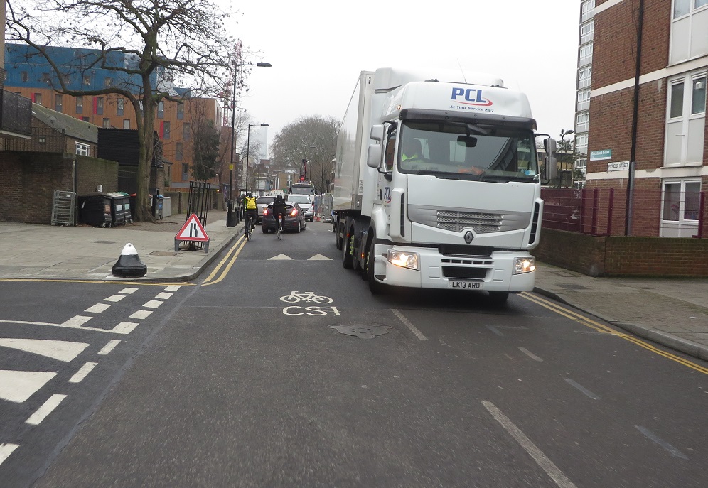
The plan in the consultation was for the vast majority of space on the "cycle superhighway" along this section to be retained to park private motor vehicles along both sides of the road, although with parking restrictions in place with no parking for five hours from 7-9am or 4-7pm on weekdays. According to the signs these restrictions are still not in place and it is free to park here before 8.30am. The restrictions wouldn't have done anything for me anyway as I tend to head down this way after 9am once I had dropped my daughter off at nursery very close to CS1 in Hoxton. I find this section one of the trickiest to navigate at that time as it seems to be full of lorries
The
Northbound contraflow cycle lane remains in the door zone and is
almost always unusable
 |
| Underneath that Lorry is a contraflow cycle lane for people cycling in the opposite direction |

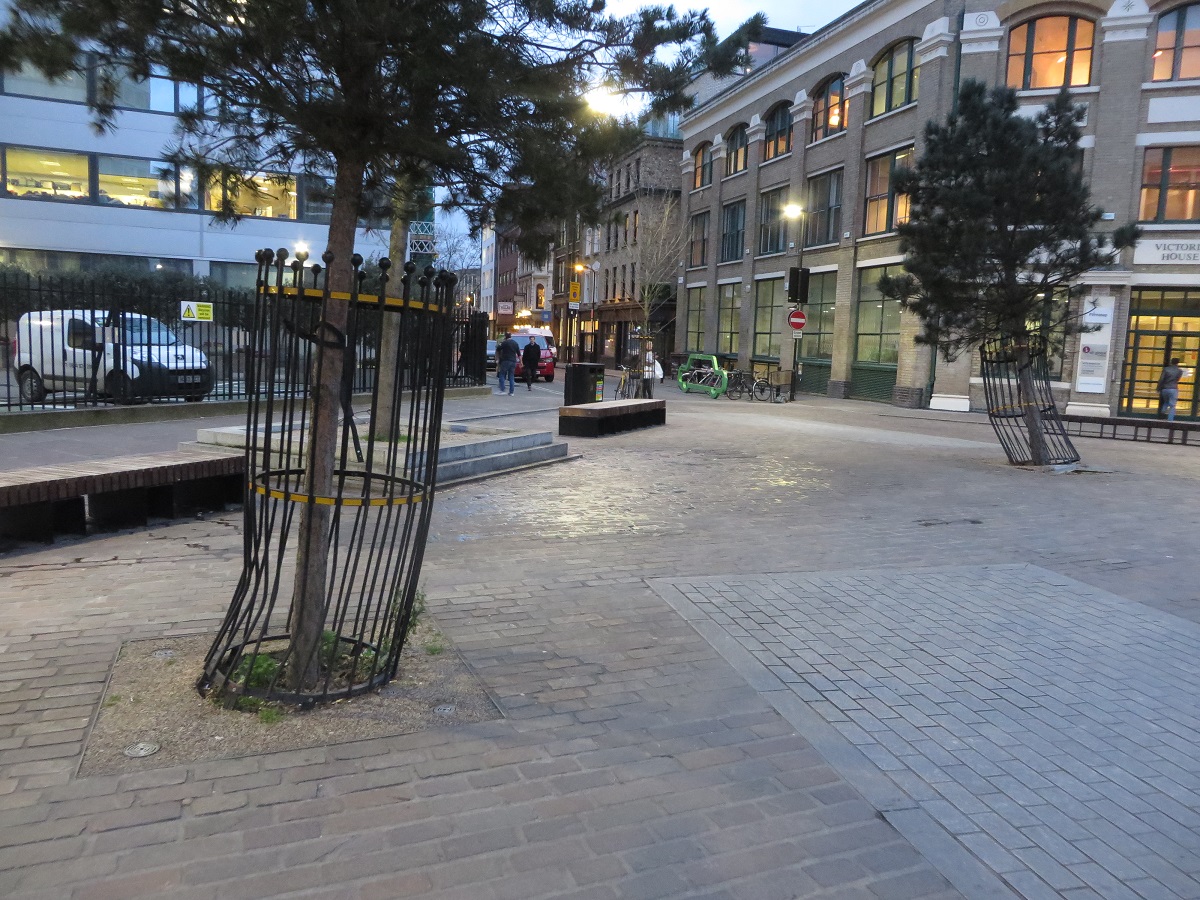
No changes were ever planned for Leonard Circus as Hackney Council spent half a million pounds turning this into a
"Dutch" shared space junction a few years ago. It could actually be quite a nice area but it is totally dominated by motor traffic. All of the cages protecting the trees have been hit and replaced (some several times) due to drivers crashing into them.
 |
| Perhaps time to put cages around the cages to protect the cages? |
Despite the claims I've never seen anything like this in the dozens of cities, town and villages I've visited in the Netherlands. I certainly can't imagine
"anyone of any age" cycling here and it must surely be awful for
visually impaired pedestrians.
 Section 3
Paul Street was meant to be resurfaced and parking again restricted for five hours a day between 7-9am and 4-7pm but neither of these happened (again you can park here for free until 8.30am) and it
remains a super-lorry-park-way.
In the original consultation the road that links Tabernacle Street to Paul Street was to be turned into another "shared space for motor vehicles, cyclists and pedestrians". However it was stated in the consultation response that this would "no longer be implimented as part of CS1 due to this being a traffic management route for developments currently under construction in Shoreditch." Which basically explains why this area is packed with lorries at peak times. The contraflow cycle track was, however, widened instead. The consultation response states that "
The London Borough of Hackney expects to redesign Taberncle Square in the future, although not within the CS1 timeframe." A translation of that is that Hackney Council will rip up the cycle track as they are determined to do this to all cycle tracks in the borough, such as in Eastway and Wick Road. As I said in the post last year this area should be turned into a pedestrianised square, with a cycle track through it, like a smaller version of
Haarlemmerplein in
Amsterdam.
Section 4
Last year I supported this proposal and stated that this was the only section of the entire course of CS1 where it actually looked like a proper cycle route.
I was, of course, being naive to think that Hackney Council would actually go ahead and build what was consulted on and promised.
 |
| Spot the cycle track? |
Instead of constructing a clear cycle track through the junction linking Pitfield Street with Paul Street they instead installed some paving complete with dreadful "shared space" signs on them, something that was not in the consultation at all and I would have been very strongly against it if it were!

The cycle track had no height difference to the pavement and was almost the exact same colour so most pedestrians did not recognise a distinction between the two and often exclaimed surprise as to why some one was "cycling on the pavement". This arrangement was dire for people cycling as well as for people walking. I assume the reason for this nonsense being built was so as a tarmacked cycle track didn't ruin the "sense of place" here, yet there is seemingly no problem with motor traffic having six lanes of very distinct tarmac, freshly resurfaced out of the cycling budget, along with speed limit of 30mph. Why not just make the whole area shared space and have thousands of lorries and buses mix with pedestrians? Because it would be absolute chaos, that's why!
 |
| The well used cycle track crossing City Road in Islington, I assumed something similar to this would be built in Shoreditch |
I was surprised, but also delighted, that in his very final act on his last day as Mayor of London Boris Johnson issued a decision
to order the removal of the shared space cycle track
The scheme which has been built differs from the visual illustrations which were in the consultation. The cycle track is not distinct in terms of surface colour and cycle symbols at most points and is labelled as space shared with pedestrians. This has caused pedestrian-cyclist conflict and confusion, with many pedestrians not realising that they are on a major cycling route. It is clear in the visualisation that was used during the consultation that the track would be marked with cycle symbols, not shared space symbols. TfL committed to “investigating the technical feasibility of further improving the colour contrast between the virtual ‘cycle track’ and the surrounding footway.” This is technically feasible and should be implemented without delay.
Serious questions remain unanswered as to how engineers were allowed to differ so much from what was consulted on and it is an absolute disgrace that public money has been spent on fixing this.
Meanwhile on the approach to the crossing from Tabernacle Square tarmac was used however, despite a promise to removed them in the consultation, the three trees that were there were left in place. In the middle of the cycle track.
 |
| The cycle track was moved and widened but the trees that were supposed to be removed to make way for it have been left there, leaving the cycle track as too narrow. An utterly ridiculous decision, why not simply have moved the cycle track further to the left if the trees were to remain? |
The former Mayor also called for
"installation of appropriate and effective vehicle blockage of Pitfield Street" and
this does need to happen, but as yet has not.
A segregated cycle track does now finally exist on Old Street if you're cycling Eastbound, between the Fire Station and Pitfield Street, but it is only around 50 metres long and so offers only a very brief respite from the appalling cycling environment of this road. It would be pleasing if it ran all the way from the Old Street roundabout (soon to be removed and gain cycle tracks) to eventually link up with the
Clerkenwell Boulevard to the West and Victoria / Olympic Park to the East
via Hackney Road. TFL state in the consultation report that it is not possible to include segregated cycle tracks as "
this route forms part of the strategically important Inner Ring Road and that segregated cycle tracks would require the removal of general traffic lanes or the cutting back of footway". Old Street here is six lanes wide, whereas the Inner Ring road either side of it on Great Eastern Street and on City Road is 'only' four lanes wide. Meanwhile the six lane section retains either a wide central reservation or right turn filtering lanes into minor side streets, such as Singer street.
 |
| There just simply isn't enough room for a cycle track here |
The very first piece of work to take place as part of CS1 last year was to build a "raised table crossing" along Singer Street where it meets Old Street when what they should have done was close it altogether. Once traffic enters Singer street it has to turn left and go through the one-day-to-be shared space Tabernacle Square and then more than likely onto the shared space Leonard Square which means motor traffic cannot be removed from Tabernacle or Pitfield Square without extensive work to change the one way system in the entire area. Although it probably suits TFL to keep rat running vans along CS1 and away from the strategically important Inner Ring Road.
Section 5
When the original consultation was launched I did not understand how turning Pitfield from one way for motor traffic into a two way road benefited cycling. Now this has occurred I can say with definite conviction that this has not benefited cycling in anyway. Closing Pitfield Street at Old Street has made it slightly quieter in terms of motor traffic northbound but this is mainly due to the ban on traffic tuning right into Pitfield Street from Great Eastern Street. Any traffic on Old Street can still access Pitfield Street by using Boot Street and stand here any day of the week and you'll see a constant stream of Taxis, vans and cars performing this manoeuvre all day long.
Before CS1 came along it was impossible to drive South along Pitfield Street for around 350 metres as only cyclists could travel southbound. Since making Pitfield Street two way the road has quickly filled up with drivers using it to access Old Street southbound,
something that could not be done before
 |
| A recent collision where a southbound driver on Pitfield Street turned left across the path of someone cycling northbound, a conflict that would have been impossible here before CS1 was built |
Leon Daniels: "Many existing and potential cyclists are not aware of direct cycle routes along quieter streets, such as the route that CS1 would follow. These plans will provide a clear and safe cycling route into central London"
One argument I have heard about this change is that this creates an opportunity to filter Pitfield Street but if this is the case when why was filtering not part of the original consultation? To make Pitfield Street a truly quiet "access only" street suitable for anyone to cycle on you'd need to close at least half a dozen roads to through traffic, something I'm not too sure would happen following the councils disastrous London Fields filtering consultation. For the time being Pitfield Street is now open for through traffic in both directions and so the only people who have benefited from this section of the scheme are drivers who now have a handy cut through south to Old Street
 |
| Surely keeping Pitfield Street one way for motor traffic (whilst also closing the Southern end of it) would have been a way to create more dedicated space for people cycling ? |
A number of "raised tables" were promised for some of the side roads along Pitfield Street, these have been carried out but continuous pavements would have been better
A small improvement for pedestrians crossing the side road here but this layout makes it look like the car has priority whereas
a continuous pavement makes it appear as though pedestrians do. In fact just north of here and a continuous pavement has actually been installed
This is past a bin store for a block of flats, a shame this wasn't trialled on some of the side roads. Also disappointing that the pavement slopes down to roadway level to help the refuse collectors who use it once a week!
Section 6
In the post looking at CS1 last year I was very much against creating yet another massive pavement here and forcing cyclists to take the lane in primary position on a narrowed road, with so much space available.
I stand by that comment, although the new green space outside the shops is very nice indeed, I can't understand why space was not reserved for creating dedicated space for cycling on the road, with so much space to play with. The new arrangement would be fine if Pitfield Street was filtered and was truly quiet but it isn't; this road can still be very busy, especially at rush hour.
 |
| School Children cycling home on CS1. Unfortunately they are using the huge pavement to do so, not the road alongside |
This is one of the reasons I was a bit dubious about the London Cycling Campaigns "
mini Holland for every Borough" pledge in the London Mayoral elections. Whilst Waltham Forest are working on some excellent schemes with the funding I fear that if you offered Hackney Council money for a mini-Holland then they would widen a lot of pavements with cyclists left on a narrower road to act as a traffic calming measure, and then label it as a cycling scheme.
 |
| Will removing cycle segregation and forcing people to cycle in primary position in front of lorries always disappoint? For the vast majority of the population of Hackney it will, yes. |
Section 7
This is one of the worst sections of the entire route of CS1 to cycle along. It is absolutely dominated by motor traffic travelling through here all day long and no measures were ever planned to change this. All that was offered here was a very slight reduction in parking and some cycle wayfinding signs.
 |
| before and after the superhighway; the cycle symbols have been removed and replaced by cycle symbols a metre further away with "CS1" written underneath them. |
I've had more close passes cycling along here in the past year than I have on every other road in Hackney put together

If you use this route on a daily basis then, whilst the majority of drivers will likely be driving safely, you will still get aggressive drivers, close passes, abuse for being "in the middle of the road" and various other situations which most London cyclists deal with on a regular basis, before many often decide the risk isn't worth it and finding alternative forms of transport
Councillor Feryal Dimirci: "This will be the first time in London that we will be creating a safe haven for cyclists and pedestrians over so wide an area"
Whilst Hackney Council do offer free cycle training they,
just like TABS, are clear that this has limitations and many people are unlikely to cycle in these conditions, trained or not.
 |
| From the Hackney Council cycling plan |
The new speed humps have been built with a smoother shape and are fine to cycle over but the reason they exist here at all tells you that this route is simply not suitable to be a "Cycle Superhighway"
 |
| A new smother speed hump on CS1 on Pitfield Street, alongside the aftermath of a high speed crash |
Mark Mascar, CS1 project manager: “CS1 is a great opportunity for people to ride and walk safely in an environment that is dedicated for them and away from traffic on some of London’s most congested roads."

Boris Johnson: "This Cycle Superhighway will provide cyclists with a direct, protected route along quiet streets, making it even easier for people to hop on a bike rather than getting in their cars."
 Phillip Glanville, Hackney Labour Mayoral candidate: "some of our roads are too narrow to provide segregation, high quality public realm, and sustain bus times. But where there is space let’s use it to improve the space for cycling and pedestrians, some of our best schemes like Pitfield Street do this, but I know there are still obstacles on these routes."

Some car parking was moved from the carriageway onto the pavement as Hackney Council are happy to give up pavement space for cars, just never for cycling
anytime I see a child cycling here it is always on the pavement and I don't blame them, this road just is not safe enough and it carries far too much motor traffic.
The google Maps streetview car even caught a couple of adults cycling on the pavement when it travelled along here this year
At the point where Pitfield Street becomes Whitmore Road we come to a crossroads, known locally as Britannia Junction, where Cycle Superhighway 1 meets LCN+ cycle route 16. No changes were planned here as Hackney Council spent £600,000 removing the roundabout here five years ago, compete with mammoth unused pavements and forcing cyclists to ride in a central position on a narrowed road. This was despite there being plenty of space available for cycling infrastructure and (although both being labelled as cycle routes) these roads being exceptionally busy with motor traffic. In the
three year period after this boondoggle project was created statistics show that
this was the most dangerous junction for cycling in Hackney, with more than twice as many cycling casualties occurring here than at any other junction in the borough. The Times also reported that this was the
7th most dangerous junction for cycling in all of the UK. Ideally the crossroads here should be removed and replaced with a roundabout, with segregated cycle tracks on it rather than creating a vanity project which focuses on places looking pretty being more important than ensuring
people travelling through those places
are safe.
 |
| A British version of a Dutch roundabout created by Paul James - ideal for a cycle superhighway |
North of Britannia Junction and they
drilled down to the old cobbles here to resurface it, reshape the speed bumps and paint CS1 and parking spaces on it. The problem is it is still dominated by motor traffic and so children cycle on the pavement, where they are safe.
 |
| Whitmore Road more than a year apart, before and after CS1 |
In my post on the consultation this is what I had to say about this section and I still think this
A horrendous place to ride a bike and the type of road which makes people give up cycling once they get to a certain age, or after a certain number of close passes. It is nothing short of a scandal that no dedicated cycling provision or removal of motor traffic is being offered here, on what is meant to be a "cycling superhighway"
I also suggested that the Georgian Whitmore Bridge should have painted cycle lanes on it with cars giving way to each other but that never happened and so parents with children cycle on the pavement here instead.
 |
| I must admit I have cycled on the pavement here with my daughter on my bike to get to the safety of the Regent's Canal from her nursery nearby, something I don't like to do but I've encountered far too many speeding, texting, aggressive drivers along here to risk it |
The only way to make this section safe and inviting for anyone to cycle on would be to turn the whole stretch one way for motor traffic to create dedicated space for cycling or close around 20 roads to through traffic.
Section 8
The improvements planned for De Beauvoir Road at Northchurch Terrace have not happened. Once CS1 turns left into Northchurch Terrace conditions improve hugely and this is the only section of CS1 that is truly suitable for anyone, of any age, to ride a bike. The reason for this is due to over half a dozen filtered roads keeping out through motor traffic creating an almost car free area. These roads have all been closed since April 1974 following effective campaigning from local residents and I've written how the closures came about
here.
The Culford Road / Englefield road junction was another part of the scheme that was used as a visualisation in the original consultation.
However this junction does not look anything like this as no works have taken place on it and so it remains a very awkward junction to cross on a bike. TFL stated in the consultation response that "
we are further evaluating the the merits of the current proposal compared with alternative design solutions, with a view to providing a solution that benefits cyclists and pedestrians, while also accommodating the needs of local residents". In my post last year I welcomed the filtering of Ardleigh Road but stated that with no filtering of Culford Road I was concerned that this scheme would actually push more motor traffic onto CS1. I was therefore delighted when TFL launched another consultation shortly later which proposed not only filtering Culford Road but also several other roads in the area to make the Northern half of De Beauvoir Town free of through motor traffic, just as the Southern half has been for over 40 years.
I was a little surprised to tune into the local TV channel London Live one morning after this consultation was launched to hear two local residents both arguing against this scheme due to the restrictions for their car journeys. One of the residents even complained that this would cost her more money per year as she would have to use more petrol to drive to her house!
One of the roads that was proposed to be filtered is Tottenham Road and local residents campaigned for this road to be closed to through motor traffic outside the school back in 1975
 |
| "Homes before roads". Members of the De Beauvoir Association campaign for Tottenham Road to be closed to motor traffic in 1975 and the same view today. |
It is wonderful to see that the filter on Tottenham Road will go on the exact same spot where local residents campaigned to close it 41 years ago. Whilst the road has remained unfit for kids for all that time local children will now be able to safely use the road to get safely to school by bike and can
safely play in the road after school as well. However I find it very sad to see in the consultation report that in 2016 the De Beauvoir Association opposed these road closures as it would lead to"
longer journey times" and also due to the "
cycling danger to pedestrians". What a difference 40 years makes; De Beauvoir Town is a
very affluent area these days and it is a real shame that some local motorists oppose these changes. Transport for London had a very good response to this in their consultation report:
As for impact on surrounding roads with displaced traffic causing congestion or additional pollution the closures will go in under an 18 month experimental traffic management order so this can be monitored and closures either revised or removed if there is significant impact. This also occurred in 1974-1975 in the Southern half of De Beauvoir Town before the closures became permanent so hopefully this can be a standard procedure when further area wide filtering is proposed anywhere in the borough in future.
Section 9
The public opted for Option B on Balls Pond Road; a bidirectional segregated cycle track running from Culford Road to Kingsbury Road. A year and three months on from committing to this
(subject to technical and operational feasibility) and nothing has happened here.
 |
| A bidirectional cycle track along Edward Street on Quietway 1 via The Ranty Highwayman - why has a similar layout not been built on CS1 yet? |
I find it odd that CS1 is listed as "delivered" when major gaps like this exist in the scheme
 |
| Local residents campaigning in the 1970's for a safe pedestrian crossing on Balls Pond Road for their children and the same spot today where a crossing now exists. A cycle track should also now exist here to allow children to safely cross by bike but as yet has not been constructed. |
Section 10
Most of the changes along Boleyn Road appear to have been carried out but these are just cosmetic changes; this road is totally unsuitable to be a cycle superhighway without drastic changes, as it is far too busy with motor traffic
 |
| Before and after CS1 on Boleyn Road |
Wordsworth Road has not been closed at the junction with Boleyn Road as was planned in the original consultation. In the consultation response it was reported that
"The London Borough of Hackney will investigate a scheme to reduce through motor traffic from surrounding roads, and make the wider area more cycle-friendly. If an area-wide scheme is not achievable within CS1 timescales, the current proposal to make the junction of Wordsworth Road and Boleyn Road cycle-only will be implemented."
Section 11
Last year I wrote the following about this section:
"Wordsworth road is a busy rat run and whilst the closure of the southern end of the road may help reduce this, traffic can still use it as a through route from the A10. Therefore Bennett Road should also be closed to ensure this can no longer be used as a through route. The roundabout should also be removed"
And I'm delighted to report that late last year, at the same time as the De Beuvoir filter consultation was out TFL ran a consultation on exactly that and Bennett Road will be filtered, along with Wordsworth Road and Salcombe Road, which will enable the removal of all through traffic from this small area. This should make a very short section of CS1 along Wordsworth Road suitable for anyone to cycle on but, more importantly, over half a dozen streets in the area will become much, quieter, nicer areas for local residents to live and safer streets for local children to use, just as is the case in De Beauvoir Town. There was some opposition from local residents to this and I do agree with them to a point; Cycle Superhighways should not be sent down residential streets. Changes such as this should occur to allow safe roads for local children, elderly and other vulnerable people to make their way by bike to the A10, or other main roads, where segregated cycle tracks await them. The fairly recently built layout at the filtered end of Wordsworth Road is not a very good layout considering the space available
 |
| The Northern end of Wordsworth Road before and after on google streetview. The cycle track is too narrow here and difficult to see, leading to possible conflict between people walking and cycling |
Below is a residential road in Breda, in the Netherlands which has been filtered. Although not a perfect layout this is what the cycle track should look like
 |
| This is not a "cycle superhighway" just a residential road filtered for local residents to use but through motor traffic is kept out. Cycle tracks are also available on main roads nearby |
Nevill Road and Defoe Road have been resurfaced and CS1 signs repainted on them but these roads are again not suitable for a cycle superhighway; they are busy, sometimes narrow and have car parking along both sides of them
Section 12
The
two new traffic islands providing a safe waiting area for cyclists crossing Stoke Newington Church Street have not been built and therefore it remains unsafe to cross Stoke Newington Church Street. This is a very busy street with over 70 buses an hour at peak times with two cyclists seriously injured in collisions at this junction in recent years. It was always a mistake to route the superhighway along here without segregated cycle infrastructure
And that is pretty much where my preview of the plans ended last year and where my review will this year as I honestly can't bear to cycle any further north along here. I haven't even seen an inch of CS1 in Harringay but from what I have seen on twitter I'm not missing much
The vast majority of Cycle Superhighway 1 in Hackney is not suitable to be called a superhighway. In fact most of it is not suitable to be called a quietway; how can a cycle superhighway contain so much motor traffic and have so many speed bumps? There is absolutely nothing super about it at all. It continues to amaze me that something like CS1 in Hackney and CS3 in Central London are two of the same thing; CS1 feels like the past and CS3 feels like the future.
Transport for London commented on routing CS1 away from the A10 in the consultation response:
"As stated in the Mayor's Vision for Cycling, Cycle superhighways need not run along busy arterial roads. Alternatives should be considered if they provide cyclists with a good level of service, as they do in this case. We are confident CS1 will provide an inviting and pleasant cycling environment for existing and, crucially, new cyclists. This supports the Mayor's strategy to normalise cycling in London. Perhaps the most successful section of existing superhighway, CS3 between Tower and Poplar, runs on side streets."
 |
| CS1 and CS3 along side streets. Which would you prefer your children cycle on? |
I've cycled from Mile End to Buckingham Palace at the weekend with my four year old along CS2 and CS3 but I wouldn't cycle along any of CS1 with her despite the fact she went to nursery right alongside it for a year! As long as Hackney continues to focus on cycling infrastructure which only suits fast, confident adult cyclists then the growth of cycling in Hackney will always be limited. I don't want to be fast when I'm cycling with my daughter; I want to be safe. CS3, CS6 (and most of CS2) manage this.
I only used CS1 after dropping her off as it was the most convenient route into Central London, now she goes to school further East I'll use the A10 instead. Cycle Superhighway 1 should be on the A10 as that is the most convenient route for most people. It would link Tottenham, Stamford Hill, Stoke Newington, Dalston, Haggerton and Shoreditch directly with the city and pass the main shops and busineses that people want to visit along the way. It could continue down to London Bridge and link up with CS3, forming a grid and truly making Hackney a cycling borough. Tweaking decades old back street cycling routes will have little effect on people taking up cycling and continuing to ignore the A10 will mean
it'll remain the most dangerous road for people on bikes in Hackney.
Anna Hughes has also written about CS1 in her blog
here.
Michal has uploaded a video of him cycling the entire route of CS1
here.